#VFR (Visual Flight Rules)
Explore tagged Tumblr posts
Visit Tumblr Blog
Explore Tumblr blogs with no restrictions, modern design and the best experience.
Last Seen Tumblr Blogs


Fun Fact
Tumblr has a 66 index score for customer satisfaction in the US.
Link
In the article "Flying in Alaska — The Last Frontier" published on The Armory Life and written by Will Dabbs, MD, the author recounts his experiences as a helicopter pilot stationed in Alaska during his military service. Hoping for an assignment in Europe, Dabbs was instead sent to Alaska, where the challenging weather and rugged terrain became his new reality. He describes the transformative experience of flying CH-47D Chinook helicopters across vast, pristine landscapes, including daring missions and breathtaking natural beauty. The narrative highlights the harsh conditions and unpredictable wildlife, such as wolves and grizzly bears, and the camaraderie formed within his unit. Dabbs shares stories of unique survival exercises and historical aircraft wrecks encountered, ultimately expressing both the hardships and the profound impact of serving in America's last frontier.
#Flying in Alaska#The Last Frontier#Alaskan aviation#bush pilots#Piper Super Cub#Cessna 180#floatplane#Alaska Range#Denali#remote airstrips#rural communities#survival equipment#flight safety#weather challenges#fly-in fishing#hunting camps#wildlife spotting#Federal Aviation Administration (FAA)#VFR (Visual Flight Rules)#IFR (Instrument Flight Rules)#aviation fuel#aviation maintenance#aviation insurance.
0 notes
Text
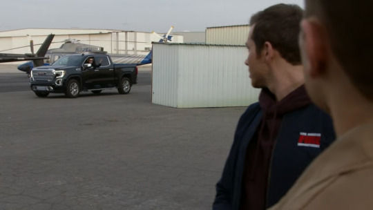
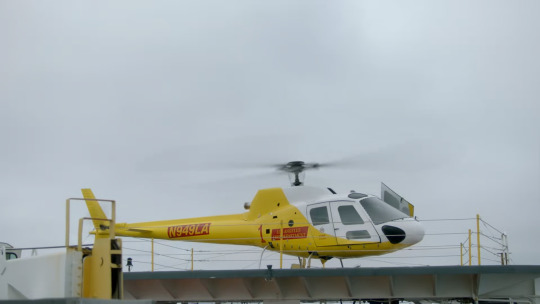
7x03 analysis part 1 — Everything Air Ops
I promised helicopters, so now we get helicopters. I want to look into how Air Operations work in the 9-1-1 universe, in comparison to its real life counterpart in this first part. Then, I will try to figure out the location and intensity of "hurricane Ethel" during the clandestine operation in the second part. And finally, I will prove how risky it is to fly a helicopter into a storm and why Tommy deserves every bit of his Medal of Valor.
Location
Real!LAFD Air Ops operate (Station 114) out of Van Nuys Airport (VNY/KVNY). It's not only one the busiest general aviation airports in the world, it's also smack dab in between major green areas of the city of LA itself.
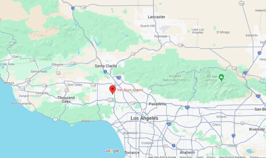
This location makes perfect sense in real life. Air Ops might get the occasional highway car wreck or urban structural fire calls, but most of their missions still consist of wildfire suppression and rural search and rescue. Being based at Van Nuys makes sure they can respond to emergency in a timely fashion.
in the 9-1-1 universe, the LAFD Air Ops are based at "Harbor Station", or Station 217. (Harbor and 217 are the same station, Chimney especially asked if Tommy was still at the 217 in 2x14 when requesting air support, unless the 911-verse LAFD has 2 different air operation units, which I highly doubt.) Obviously it has to be at an airport, because that's where the hangers and helipads are, and going by "harbor" I can only speculate that it's in the Harbor Region of LA.
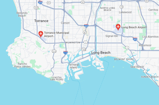
The only non-military airport in the LA Harbor Region is Long Beach Airport (LGB/KLGB), but it's quite a busy commercial airport, probably not a good one to run emergency services from. There's also the Zamperini Field (TOA/KTOA) nearby in Torrance, although not exactly inside the Harbor Region, it's coastal and close enough to the 2 LA ports I guess? Feel free to create a whole new airport using your imagination though, as you know 9-1-1 is set in an alternate universe where geography and physics work differently.
Helicopters
The LAFD Air Ops have 5 medium (FIRE 1-5) and 2 light duty (FIRE 6/7) helicopters, you've heard Tommy in 7x04. Everything applies to the real world counterpart, but the medium type that real!Air Ops operate is AgustaWestland AW139, the Italian-made medium sized twin-engine helicopter with a 5-blade main rotor primed for emergency response and off-shore oil rig transportation.
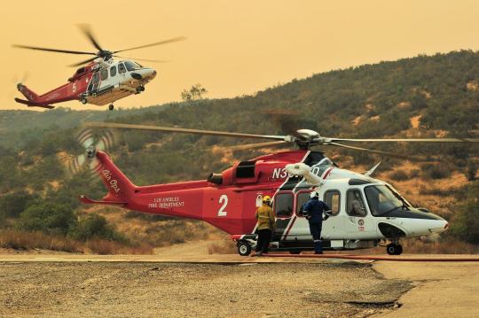
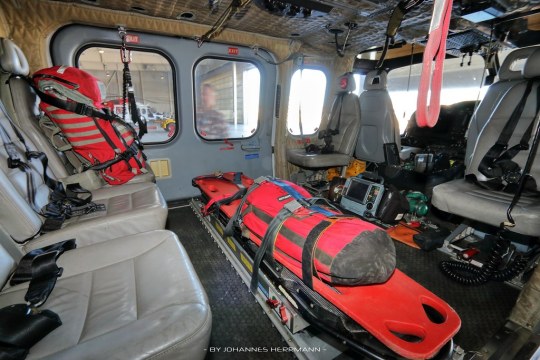
It has auto-pilot, an anti-icing system for harsh weather and even auto-hover suitable for hoist rescue missions. In a passenger transport configuration, it can carry up to 15 passengers in a 3 row seating plan. In an SAR (search and rescue) configuration though, the middle row can be removed for gurney space. It's big and powerful enough to transport multiple patients, but at the same time, light and agile enough to get into difficult terrain.
The AW139 is designed to be flown by 2 pilots, flying solo is also possible, but only under VFR (Visual Flight Rules), with an additional certification, which LAFD pilots can and do. To fly it under IFR (Instrument Flight Rules), it always requires 2 pilots according to the FAA last time I checked.
The light helicopter type real!LAFD flies is the Bell 505 Jet Ranger X, a single engine twin-blade made in Canada. It's an relatively new airframe, set to replace the aging Bell 206, which the LAFD used to operate. It's quite a bit smaller than the AW139, it can only fit 1 pilot and 4 passengers.
While it's perfectly capable of carrying a Bambi bucket to assist with aerial firefighting missions, it's mainly used as a training aircraft for new pilots and HLCO (Helicopter Coordinator) when there is a major catastrophe that requires on-the-site air traffic coordination.
These are all brand new and sophisticated aircrafts that a mere TV channel can't get their hands on without a government budget. So for 911!LAFD Air Ops, ABC went to their usual helicopter service company for prop aircrafts.
Helinet Aviation provides all sorts of helicopter services from aerial journalism, medevac, delivery to regular chartering. All the 911!Air Ops scenes in 7x03 and 7x04 are naturally filmed in the Helinet hanger, for convenience's sake, at VNY, just a runway across from real!Air Ops.
911!Air Ops

Helinet hangar Street View
I believe I've identified all the helicopters shown in 7x03 and 7x04, but let's get the 2 in the background which probably do not belong to 911!Air Ops out of the way:
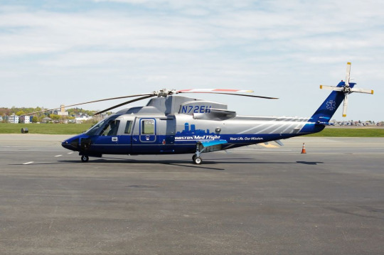
N72EH, a Sikorsky S76C++, still in its Boston MedFlight livery. Sold to Helinet in 2022, possible used as a medevac vehicle currently? Unlikely to have anything to do with 911!Air Ops, probably just happened to be in the background to make it seem like there were many helicopters.

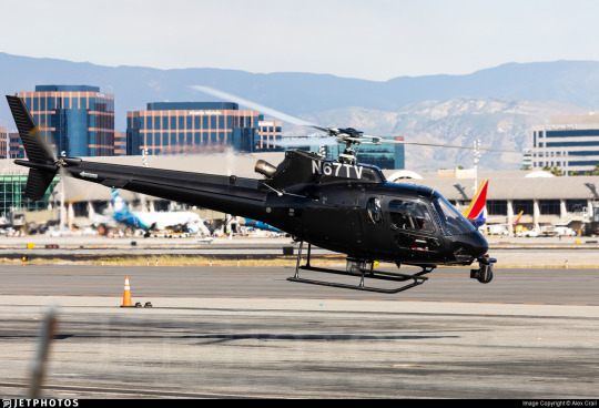
The one Tommy flies Eddit to Vegas in is N67TV, an Eurocopter AS350B2 Écureuil (aka squirrel). No fire department would ever let employees take their expensive equipment out for a joy ride so it's likely that in universe, Tommy rented it from somewhere outside of the station. IRL though, according to this forum post, it's used as a backup helicopter for all its customer news stations, but also any TV or film production purposes outside of journalism.
Now, for the one seen in the hangar, therefore explicitly belonging to 911!LAFD:

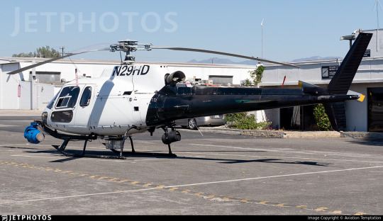
N29HD, also an AS350B2, also a news helicopter. According to this reddit comment, it used to be shared between CBS and FOX, but now it seems to be configured as a dedicated aircraft for ABC7.
The one the who cares gang stole to rescue Bobby and Athena though has a fake registration number on it:
You just have to look up Helinet's fleet, and you will see this is obviously a DHL livery, and it's quite easy to find out that this is actually:
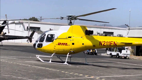
N211FN, an AS350B1 (so an even older variant than the previous two), operated on behalf of DHL for package delivery service.
Don't get me wrong, the AStar (how the AS350 is called in the US) is a versatile and reliable aircraft. It the 4th most produced rotorcraft in the world, someone even managed to land one on top of Mount Everest. But it's kind of small? It can seat only up to 5 passengers with 1 pilot, and there is hardly room left for any gear. There is also no space for stretcher, so anyone they rescue would have to sit upright. It's just not very realistic.
I have no idea what medium duty helicopters 911!Air Ops operate, we're unlikely to see them in the future. There is this Bell 205 in 4x12 Treasure Hunt, but it clearly says L.A County Rescue on the tail.
youtube
Pilots
Real!Air Ops pilots wear beige flight suits, it's the aeromedics who wear blue, and helitac crews wear orange. I'm not complaining too much though, Tommy looks good in blue. (I think the chief pilot wears dark blue, but I'm not sure.)
Helicopter pilots in general usually wear helmets, in case a particularly strong pocket of turbulence slams you against the body of the aircraft, or a bird decide to fly through the windshield into your face, but I get that it gets in the way of the camera, so I'm just gonna enjoy Tommy's beautiful face.
Real!Air Ops pilots work on a 24/48 shift schedule just like any platoon firefighters. Due to the danger of pilot fatigue on aviation safety, they do try to limit their continuous flight time to 6 hours before taking a prolong break.
There are 5 levels of pilots: pilot I (trainee), pilot II (probational), pilot III (full pilot), pilot IV (lead pilot) and pilot V (chief pilot). The chief pilot oversees the entire Air Ops and work on a 10 hour per day, 4 days a week schedule. The rest of the pilots are put into 3 shifts, each shift with a pilot IV, 2 pilot IIIs and 2 trainees/probies, together with 4 aeromedics. (Can't find the most updated version, the lastest one I can get my hands on is from 2022, so good enough?) Therefore Tommy's Bobby would not be a captain, it would be a lead pilot.
I've already explained in detail the timeline of Tommy's career as a firefighting pilot, but here is the short version of it: Once accepted into the LAFD pilot training program, he would have to train with the LAPD for 180 hours then back to the LAFD for 200 hours, that takes around 2 years, and by then he would be a probie. After that, he would have to slowly build up flight hours then train and certify for all types of missions on the medium duty helicopter, that would take another 2-3 years, and after that he would be promoted to a pilot III, which is probably the rank he holds now.
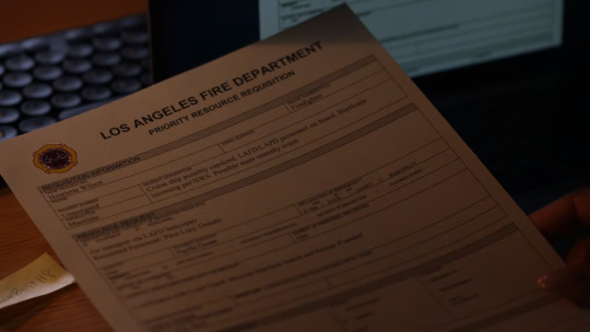
We can see from the form Hen submitted in 7x03 that she initially asked for Lucy as their pilot, as she's forgotten that Tommy also worked there. Fortunately Chimney called Tommy, as Lucy most likely would've still been a probie if not just a trainee.
Melton
I have no idea who he is.

I can sort of see his badge says "firefighter"? At real!Air Ops, everyone wears a flight suit as uniform, so that they can hop into a chopper in an emergency. I don't know what a dude in a regular uniform with the regular LAFD patch on his arm doing there.

Tommy's arm has the Air Ops helicopter patch on it.
Real!Station 114 though do have a crash unit staffed with regular firefighters, maybe Melton is with them? But then, why is he doing with Hen's helicopter requisition?
#911 abc#911 on abc#911 show#911 meta#tommy kinard#tagging the ship for fic writing reasons#bucktommy#tevan#kinley
110 notes
·
View notes
Note
what does "bust a bravo" mean
smile
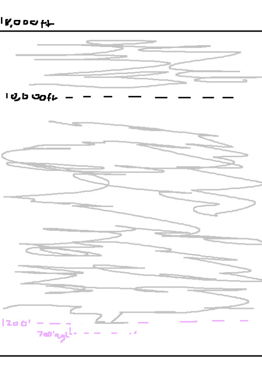
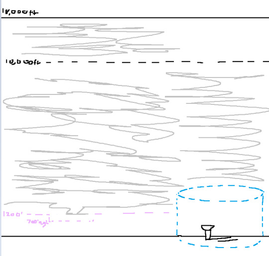
ok gang! lets learn about The National Airspace System! (referenced with AIM chapter 3 and PHAK chapter 17)
We'll start off easy with Uncontrolled Airspace! Class G or Golf airspace is Completely uncontrolled. Theres nobody there watching to maintain spacing or really anything, however you still have to maintain the minimum weather requirements for Visual Flight Rules.
Those rules are as follows, For Daytime flying less than 1200 feet Above Ground Level (hereby condensed to AGL), you must maintain 1 statute mile of visibility (think fog obscuring how far you can see) and remain clear of clouds. For Daytime Flying above 1200 AGL its 3 Statute miles of visibility, 1000 feet above clouds, 500 ft below, and 2000 feet horizontal. if its Night time flying below 1200ft AGL, its 3 statute miles, 1000ft above, 500ft below, and 2000ft horizontal around clouds. These numbers are very Very common, and will be condensed into the "3-152" Rule. Night time above 1200ft AGL is also the 4-152 rule.
NOW! Where IS class Golf airspace? Well, it starts from the surface all the way up to 1200 feet AGL. Sometimes its to 700ft AGL but we'll explain why that is when we get into Controlled Airspace.
so basically it looks like Such:

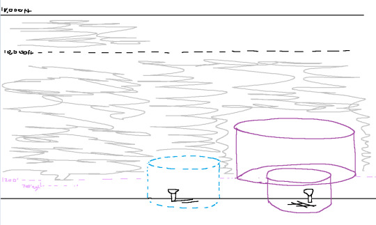
Next up: controlled Airspaces!
first one is class E or Echo, which stands for EVERYWHERE. Where is Echo? EVERYWHERE but uncontrolled, or other Defined airpspaces. Class Echo starts at 1201ft AGL, and goes alll the way up to 17,999ft MEAN SEA LEVEL. Mean sea level (or MSL) is the height above where the ocean Approximately is. So if you're 0ft MSL, you're basically swimming. All (most.) aircraft Altimeters (the instruments that tell you how high you are) are calibrated to what the air pressure outside is at mean sea level and indicate how high they are compared to where MSL is.
Back to Class E airspace. E goes up to 17,999ft MSL, because at 18,000ft it changes to a different airspace, which we will get to in a moment. So, Class E is Controlled airspace, but that doesnt mean you have to be talking to people to fly in it. in fact, most people flying in class E arent actually talking to air traffic control! most of the time they're flying around Visually, under Visual Flight Rules, which means "i can see outside and where im going, and i can navigate this way."
so how do you fly in E under Visual flight rules? well, by flying in it. but they do have to have weather minima above the 3-152 Rule. Except over 10,000 ft, which is when it changes to 5-111. 5 Statute Miles visibility, 1000 feet above, 1000 feet below, 1 mile horizontal.
Class E also has Speed regulations! anywhere under 10,000ft is limited to 250 Knots (nautical mile per hour) and above 10,000 its just. mach 1. you cant break the speed of sound. FUN!
in some specific areas, (most of the time over airports) the Class E airspace is Lowered, to allow the controlled airspace to be closer to an uncontrolled airport. This is visualized on a VFR sectional chart as a shaded magenta area, kinda looking like a circle. This lowering is done for Instrument Flight Rules purposes, but im not an Instrument flight instructor so i cant teach on that yet. sorry.
so basically, E looks like This:
Next up is the Fun ones!
Class Delta airspace is usually surrounding a 5 statute mile radius around a Towered airport, from the Surface to 2500ft AGL. Some airports don't have towers, which places them in Uncontrolled airpspace, aka Class Golf! you can just take off and land however you want! on towered fields however, you have to maintain two way radio communication with the controlling agency of the field. you're flying around, 10 miles out you go "Gateway Tower, Skyhawk N123AV, 10 miles to the south, full stop" and they reply "Skyhawk 3AV, enter left base runway 9." once you hear your callsign "skyhawk 3AV" you know you're allowed into the airspace, unless given specific instruction otherwise.
Class Delta has the same 3-152 rule for VFR. and is depicted on a sectional chart as a dotted blue circle around an airport.
it looks as Such:
Next up, is class Charlie, or C.
Charlie is a lot bigger, think your local international airport. Nashville, Tucson, Oklahoma city, Little Rock. These are Big airports, but not like. HUGE. not like atlanta or JFK or LA. those are their own catagory which we will get to.
Class C is defined as a 5 mile radius from surface up to 4000 ft AGL! a lot taller! But, theres a catch~ theres an outer circle, with a 10 mile radius, from 1200ft agl to 4000ft agl. think an upside down wedding cake with tiers. they can change around to have more than just 2 different sections but most class C's look like this.
VFR is 3-152, and you must have 2 way communication to enter their airspace. however, because this airspace is so much bigger, they usually have an Approach controller, who you contact before getting close to the tower. they have different controllers to contact for different directions you're coming from. Fun! you also need to have a Mode C transponder. this is a device that sends information to ATC's Radar, giving Altitude information and a dot of where you are on their little map.
They're Depicted on a sectional chart as solid magenta lines, as opposed to shaded magenta lines
Class Charlies:
Finally. we get to answer Anon's BURNING QUESTION: what is "busting a bravo?"
well, we must talk about Bravo airspace. B, stands for BIG. not really, but like, these airspaces are extremely complex, absolutely massive, and are routed specifically for the airport and its arrivals, departures, and approaches. they're highly customizable and very fun to deal with! (lie)
these are your Pheonix sky harbors, your JFK's, your LA's, your San Diegos, your Atlantas. Massive Airports with EXTREMELY high traffic, and airports very close by.
For class bravos, you only have to be 1 statute mile of visibility, and clear of clouds, day or night, to operate VFR. but what are the chances you're operating vfr in a bravo anyways? not very high. still need to know that for a checkride, though. theres also a 30nm ring surrounding them, which requires a Mode C transponder inside of that "mode C veil"
Class bravos are signifigantly more strict on whos allowed to fly into them. before, in D or C, you just needed to hear your callsign and be able to enter, otherwise you'd be busting through their airspace. However, with class Bravo? you have to be Cleared into the bravo. they have to say "Skyhawk N123AV, you are Cleared into the class bravo airspace" before you're allowed in. otherwise, they WILL call your ass over the radio and go "skyhawk N123AV, were you cleared into my airspace?" "skyhawk n123av, no." "alright, skyhawk N123AV, i have a number for you to call when youre on the ground, advice ready to copy" which indicates you are FUCKED. you have to call and explain why you were in that airspace when you were not supposed to be. this is a very very bad thing and Not something you want on your record.
But!!!! if you're busting that airspace as a student, your CFI is at fault, because they're the one supposed to be seeing and avoiding, and preventing you from breaking airspace you shouldn't be.
anyways, Bravos are depicted as solid blue lines on a sectional chart, and "look like this":

woof! thats a lot! and every airspace we gotta think about!
hm? whats that? i forgot one?
oh right! above 17,999ft! thats right! well, thats Class Alpha airspace! its the most controlled and restricted airspace, because you CANNOT operate under visual flight rules in there. at all! you must be under Instrument Flight Rules to fly in class Alpha airspace. once you pass 17,999, you enter the "Flight Levels" which are indicated as FL180, and go all the way up to FL600, or 60,000 ft. thats, really high up. Nobody goes up there, except the SR-71 blackbird. You really dont ahve to think about class A until you get to your Instrument rating, which im not qualified to teach, so. scram.
if you have ANY questions or think i missed something, feel free to correct me, i dont know everything. once again i referenced AIM chapter 3 and PHAK chapter 17 for all of this information.
30 notes
·
View notes
Note
I don't write but I am interested in what you would recommend for writing about preparing for a flight in a light aircraft realistically. Even for drawing. While reading your blog I remembered some story or something describing a scene in the back seat of a small plane like a cessna 172 and I just couldn't imagine any of it well because i know that space is too dang tight.
Also, just out of curiosity
What are some examples of planes that you can instruct in? Are we talkin cessna or piper or beechcraft or?
Hi!
I instruct in the Piper PA-28 series of aircraft, and a basic flight plan is typically done in the few hours preceding a flight, or the night before in the case of an early-morning flight.
Step one is to determine where you want to go, and if the weather will even allow for it to happen. Assuming you're in the USA, aviationweather.gov and 1800wxbrief.com are the two most useful websites for flight planning. This step is a "big picture" glance at the route of flight, and this is when you actually draw your lines on a map to plan out your route.
Once the weather looks okay and your route is planned, the next step is to designate a set of "checkpoints" along your route of flight, be they landmarks on the ground for VFR (visual) flight, or navigation waypoints for IFR (instrument) flight. The purpose of these is not only to remember what to look for, but to help figure out your ETA with some math you'll be doing later in the planning process.
All of these waypoints are written down in a document called a nav log, which is essentially a table describing your route, the waypoints along them, estimated speeds, estimated times, etc. Once all of your waypoints are picked out, you tally up the distances between them (in nautical miles), and make sure that number matches the total distance.
Now, with your route and waypoints, it's time to take a closer look at the weather. Since we already know we'll be clear of any nasty weather, now is the time to focus on one important thing: what the wind is doing.
Using the websites above, we can get a forecast of the wind speed and direction at our desired altitude, which is chosen based on what provides the best tailwind (or least-bad headwind). Our altitude, assuming a VFR flight, follows the hemispherical rule - eastbound flights fly at an odd-thousand altitude plus 500, and westbound flights fly at an even-thousand altitude plus 500. Add the wind speed/direction, as well as the desired altitude, to the nav log.
Now, here's the part where we do the math, and for this, we'll use a special calculator called an E6B. It's a slide rule whose design has been almost unchanged since the Second World War, and it can do unit conversions, course corrections, fuel burn calculations, and much more. What we want right now is the wind correction function - given a desired course, a wind speed, and a wind direction, it can calculate a ground speed (faster with a tailwind, slower with a headwind), as well as a wind correction angle, which is a heading to keep the airplane from being blown off course by the wind.
We need to do a wind calculation for each of our waypoints, adding the wind correction and ground speed to our nav log.
Now that we have our estimated ground speeds at each waypoint, we calculate our estimated time enroute (ETE) between each waypoint, again using the E6B to do so and adding the results to the nav log. Add up the ETEs between each waypoint to get an ETE for the entire route.
After that's done, we'll calculate how much fuel we need. Consult the airplane's manual for a fuel burn measured in gallons per hour (GPH), which is 9.5 GPH for the PA-28. Do the math with the E6B, and you now have your cruising fuel.
Next, climb fuel - for this one, you need to consult the airplane's manual, and follow the directions on a graph to get this number.
Finally, reserve fuel - for a VFR flight during the day, you need enough fuel to cruise to your destination, and then fly at a normal cruising speed thereafter for 30 minutes.
For a VFR flight at night, or an IFR flight, you need 45 extra minutes of fuel, plus any fuel needed to fly to an alternate airport in the case of IFR.
Those are the basic elements of a flight plan, but there's more that pilots are required to familiarize themselves with:
- NOTAMS (notices to air missions; typically concerns airport closures or non-standard procedures)
- Weather information (it's always good to do one more look at the weather, and also obtain a weather briefing for your route of flight)
- Known delays (ground stops, busy airspace, etc)
- Runway lengths at airports of intended use
- Alternative airports to land at if your destination is no longer suitable
- Fuel requirements
- Takeoff and landing performance numbers (can your airplane take off and land within the length of the shortest runway you plan on using?)
- Any other information pertinent to the flight
11 notes
·
View notes
Text
Been seeing a lot of commentary and just blatant misinformation (from both individual posters on social media and the mainstram media themselves) on the DC mid air collision, so I wanted to make a post with some nuance to clear up the situation.
The details of the accident seem pretty straight forward using the ATC recordings but it's important to let the NTSB do their job and publish their own probable cause after an investigation.
First some background on the aircraft involved and what they were doing just prior to the collision.
American Eagle 5342 was a Bombardier CRJ700 operated by American Airlines on an IFR flight from Wichita, Kansas to Ronald Reagan Nat Airport, DC.

When an aircraft flies IFR (Instrument Flight Rules) they make and file a flight plan that includes very specific routes and altitudes to get from one airport to another and they are in constant communication with ATC. Think of it like driving on the highway from one city to another. You use an on ramp (departure procedure) to get out of one city and onto the highway (en route structure and airways), then get off the appropriate exit (approach procedure) to end up in another city.
Different airports will have different approach procedures depending on the runway and the navigation equipment being used. In some cases you can use the approach to one runway to descend down to the airport and then perform a "circling approach" where you break off at a certain altitude and circle around to land at another runway. This is what Flight 5342 was cleared by ATC to do before the collision.

The jet used an approach to runway 1 with a circle to land clearance for runway 33. This meant it made a right turn from the south of the airport at a low altitude before making a left turn to set up for a final straight in leg to runway 33. None of this is unusual for an airliner to do.
The helicopter involved was a US Army UH-60 Black Hawk helicopter under the callsign PAT25 making a routine VFR flight southbound down the Potomac river.

Under VFR (Visual Flight Rules) an aircraft navigates by visual reference to the ground and landmarks, largely or fully independent of ATC guidance. However the helicopter was within the boundaries of Reagan airport's airspace, where they would need to be in communication and radar contact with the control tower. The helicopter was navigating through the airspace along a published helicopter route where they would only need clearance to enter the airspace and then navigate the route themselves.

They were flying along route 1 to route 4 southbound (top left of the chart to bottom center). This route has a published maximum altitude of 200 feet above the ground but ADS-B data shows the helicopter at 400 feet which should have been corrected by the pilots and/or notified by ATC.
So with the helicopter above its required altitude and the jet circling through their flight path a collision would be imminent but still avoidable.
When aircraft are flying near each other in some controlled airspace they will be issued traffic alerts from ATC. This would sound something like "ABC123 Traffic 9 o'clock 4 miles at 1500 report them in sight". At that point you would have a decent idea of where to look and scan for that traffic before replying whether you had them in sight. After you've been notified you'd build and maintain that situational awareness to avoid them.
When the helicopter was notified that the jet was making a circling approach to runway 33 they reported the traffic in sight and requested visual separation, which was approved by ATC. Now it was up to the helicopter to keep the other aircraft in sight and either slow down or alter their flight path slightly to pass around and behind the landing jet.
Again, nothing unusual about that. The problem was the flight was occuring at night where the only way to spot traffic is by their exterior lighting.
I've been on night flights through very busy airspace and seen a long line of airliners on approach to parallel runways and if the lights weren't at different altitudes, I'd have no idea which ones were further or closer to me. At night a plane thats at 10 miles away looks awfully similar to one that is only a mile away.
I believe the accident was primarily caused by the helicopter spotting the wrong aircraft and not noticing the much closer jet circling to land. Behind the CRJ was another flight also on approach to runway 1 that was probably spotted instead.
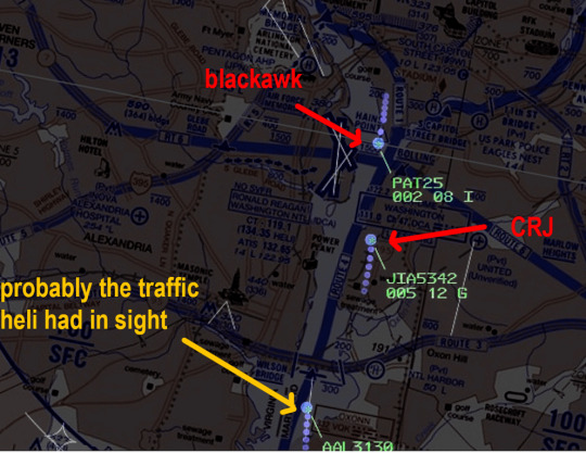
With the helicopter focused on that aircraft and the jet focused on landing their aircraft. To top it off, ATC again asked the helicopter if they had the traffic in sight when they appeared to still be closing, which the helicopter confirmed they did. A few seconds later the mid air collision happened.
I wont assign fault to any one part but I expect the helicopter route chart, ATC guidance, the approaches, and crew training for all parties involved to be revised.
The media on both sides is trying to make a political spectacle for the crash, blaming shit like DEI or the incoming Trump Administration. Ive even seen those demanding to see the "black box" data to somehow prove what caused the accident. The flight data recorder aka "black box" will only tell you that both aircraft were operating normally prior to the accident, and hopefully some crew conversation to glean info about the state of their awareness.
This is the deadliest US air travel accident in nearly 20 years and it sickens me how ignorant nearly all media is when reporting on it.
5 notes
·
View notes
Text
Here's the 1958 collision: https://en.m.wikipedia.org/wiki/United_Air_Lines_Flight_736
I just want to say: see and avoid is still the rule for Visual Flight Rules (VFR, read: recreational) pilots. And it works great... if you're flying one of these

Top speed of a little over 100 miles an hour. For the most part, this is the kind of performance you could expect up to World War II. The primary airliner was the DC-3, which cruised at about 200 mph. There were relatively few aircraft in the sky. Perfect? No. Functional? Quite.
By the time the late 50s rolls around, there are a LOT more airplanes in the sky going a LOT faster. Your average airline is cruising at over 400 MPH and the airlines are in the process of driving passenger rail out of business, filling the skies with planes. The military airplane in question is this

With a top speed over Mach 1, though was probably subsonic during the collision. As noted above, a collision would be nearly unavoidable at those speeds.

I’m convinced it was an interdimensional portal
111K notes
·
View notes
Text
🛫 VFR vs IFR – Know the Difference

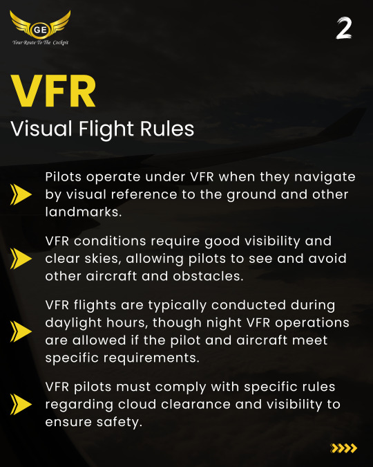

Whether you're an aspiring pilot or an aviation enthusiast, understanding the difference between Visual Flight Rules (VFR) and Instrument Flight Rules (IFR) is essential.
✈️ VFR: Relies on visual cues – great for clear skies and daylight flying.
🛩️ IFR: Depends on instruments and ATC – perfect for poor visibility and structured airspace.
🔍 Stay informed. Fly smart.
💡 Want to know which suits your training goals best? Drop your questions below!
#VFRvsIFR #PilotTraining #AviationBasics #AviationKnowledge #LearnToFly #FlightTraining #DGCAIndia #IFRTraining #AviationIndia #GoldenEpaulettesAviation #FlyWithClarity #AviationFacts #PilotLife #FlightSchoolIndia #StudentPilot
Pilot, Aviation, Career, Scholarships, Training, Success, Future, Dream, Flight, Groundclasses, GoldenEpaulettesAviation, Instructors, Opportunity, Growth, Journey, Education, Guidance, AviationIndia, HowToBecomeAPilot, DgcaGroundClasses
#aviation#dgca#dgca ground classes#pilot training#dgca cpl classes#pilotlife#aircraft#us navy#airplane
0 notes
Text

Learn the differences between VFR and IFR in aviation. Understand how pilots navigate using Visual Flight Rules (VFR) and Instrument Flight Rules (IFR) for safe flying.
0 notes
Text
Adverse Weather Disrupts Domestic Flights in Nepal
Adverse weather conditions have disrupted domestic flight operations across Nepal, with reduced visibility being the primary issue. While Tribhuvan International Airport (TIA) in Kathmandu continues to operate both domestic and international flights under Visual Flight Rules (VFR), flights to many regional airports remain grounded. According to TIA spokesperson Rinzy Sherpa, airports…
0 notes
Text
What You Can Do with a Private Pilot License: Opportunities and Limitations
Obtaining a Private Pilot License (PPL) is a significant achievement for aviation enthusiasts. It represents freedom, adventure, and the beginning of numerous flying opportunities. However, while a PPL opens many doors, it also comes with certain limitations. Here’s a closer look at what you can do with a PPL, along with the restrictions you should be aware of.
Opportunities with a Private Pilot License
1. Personal Travel One of the most exciting prospects of holding a PPL is the ability to fly yourself and passengers for personal travel. Whether it's a weekend getaway or visiting remote locations, a PPL allows you to bypass commercial airline schedules and explore destinations at your own pace.
2. Recreational Flying For many, the joy of flying itself is the primary reward. With a PPL, you can enjoy leisure flights, explore local airstrips, and participate in fly-ins and airshows. The sky becomes a playground for those who love the thrill of aviation.
3. Sightseeing Flights Share the beauty of flight with friends and family by taking them on sightseeing tours. While you cannot charge for these flights, the experience is often rewarding enough on its own.
4. Access to a Variety of Aircraft With a PPL, you can fly different types of single-engine aircraft. As you gain experience, you can pursue additional ratings and endorsements to expand your capabilities, such as flying multi-engine planes or seaplanes.
5. Foundation for Further Certifications A PPL is the first step toward more advanced pilot certifications. Whether you aspire to fly commercially or want to enhance your skills with an instrument rating, your private pilot license is the foundation for further aviation pursuits.
6. Join Aviation Communities Being part of the aviation community is a rewarding experience. You can join flying clubs, participate in group flights, and connect with fellow aviation enthusiasts who share your passion.
Limitations of a Private Pilot License
1. Non-Commercial Use A PPL does not allow you to fly for hire or compensation. You can share flight expenses with passengers, but you cannot profit from your flights. If you wish to pursue a career in aviation, you'll need to obtain a Commercial Pilot License (CPL).
2. Daytime and VFR Only Unless you obtain an Instrument Rating, you are restricted to flying under Visual Flight Rules (VFR), which typically means good weather conditions and daylight. This limits your ability to fly in adverse weather or at night.
3. Aircraft Type Limitations With a standard PPL, you are limited to single-engine, non-turbine airplanes. To fly more complex aircraft, such as jets or helicopters, you’ll need additional training and endorsements.
4. Passenger and Distance Limitations While you can carry passengers, the number is limited by the aircraft's capacity. Additionally, cross-country flights require careful planning regarding fuel stops, weather considerations, and airspace regulations.
5. Currency Requirements To maintain your PPL, you must meet specific currency requirements, including a minimum number of takeoffs and landings within a certain period. Staying current ensures your skills and knowledge remain sharp.
Are you prepared to embark on an exhilarating journey to elevate your passion for aviation to unprecedented altitudes? Look no further than Indowings Flight Training Academy, to cultivate your potential and arm you with the requisite expertise and proficiency to navigate the skies with confidence.
0 notes
Text
Journeys With the Air: The Development and Significance of Aircraft Flight Charts
Aircraft charts, also known as aircraft flight maps, are among the most important instruments in aviation. They act as visual aids for pilots, providing information on airspace restrictions, route layouts, navigational aids, and other pertinent details that they must be aware of while in the air. These maps, which have undergone substantial development over time, optimize flight paths to improve air travel efficiency while also guaranteeing flight safety. The fascinating development, history, and significance of aircraft flight maps will all be covered in this article, along with how these vital instruments assist pilots in navigating the wide sky.

The Early History of Aviation and Simple Navigation
The initial flight maps were simple and undeveloped. When aviation first began, pilots mostly used landmarks like rivers, mountains, and cities for navigation. The first means of "navigation" was based on visual cues and was heavily reliant on clear weather. Paper maps were a common tool used by early pilots, such as those in the Great War, to aid in navigation over unknown or foreign terrain.
But this was not always a reliable way to navigate, particularly at night or over wide bodies of water or desert. A more accurate method for determining one's position and course in the air was required by pilots. As a result, increasingly advanced maps and navigational aids were created.
The Aircraft Charts Introduction
The need for specialized maps created especially for pilots emerged as aviation grew. The 1920s and 1930s saw the introduction of the first aviation charts, which included airways, terrain elevations, and landmarks. These maps included essential navigational aids that helped pilots find their location more precisely, like radio waves and communication frequencies.
Airways, or predetermined flight paths in the sky, were established, which was a significant improvement in aviation efficiency and safety. These airways were created to steer planes safely around impediments like mountains and restricted airspace. These airways were first included in early aeronautical charts, which signified the start of contemporary flight navigation as we know it today.
The Development of Navigational Helps and Flight Maps
After World War II, flight maps became more standardized and detailed in the decades that followed. New technologies, such as the development of radio navigation systems, significantly enhanced the accuracy of these maps. Pilots could now more reliably follow established paths thanks to the advent of VOR (Very High Frequency Omnidirectional Range) and NDB (Non-Directional Beacon) navigation systems. These systems were incorporated into flight maps, allowing pilots to plot their course with greater precision.
Additionally, restricted zones, no-fly zones, and airspace classifications were added to aviation charts to help pilots stay within approved flight lanes and avoid potential hazards. Flight maps became indispensable with the introduction of controlled airspace to make sure that aircraft followed designated routes, especially in congested areas close to airports.
Types of Flight Maps for Aircraft
There are various kinds of flight maps, each with a distinct function, that are made for various stages of a flight. From takeoff to landing, these maps support pilots in planning and executing their flights, giving them the information they need to navigate safely and effectively.
1. Charts for Visual Flight Rules
Pilots who fly under Visual Flight Rules, or who primarily navigate by visual reference to the ground and weather conditions, use VFR charts. In addition to airspace boundaries, restricted areas, and important navigational aids, VFR charts highlight important landmarks like cities, roads, rivers, and topographical features. For pilots operating at lower altitudes where they must have unobstructed visibility of the ground, these charts are essential.
2. Charts for Instrument Flight Rules
A distinct set of charts is used by pilots operating under Instrument Flight Rules, as they primarily use instruments for navigation instead of visual aids. Airways, waypoints, navigational aids, airspace organization, and approach procedures are all shown on IFR charts. These charts are intended to offer comprehensive guidance on safe flight paths, especially when operating at higher altitudes or in inclement weather.
3.Charts of Terminal Areas
Major airports are served by the use of terminal area charts. These charts offer comprehensive details about the intricate airspace and protocols that surround crowded airports, including altitude limitations, approach and departure routes, and navigational aids. In order to guarantee safe arrivals and departures in crowded airspace, TACs are crucial.
4.Travel Maps
Enroute charts are used to navigate between airports and cover large distances. The network of airways, navigational aids, and altitude levels that pilots use during the cruise phase of flight are depicted in these charts. They also show the controlled zones and airspace limits that an aircraft must fly within.
5. Charts for Approach and Departure
Pilots are guided by these specialized charts during the crucial stages of approach and departure. Approach charts offer comprehensive landing instructions, including missed approach procedures, navigational aids, and altitude requirements, for a given airport. On the other hand, departure charts offer details on the most effective and safest way to leave an airport and enter the enroute structure.
The GPS and Contemporary Navigation Systems' Effects
The Global Positioning System (GPS) was one of the most revolutionary innovations in the field of flight maps. GPS technology provided real-time positioning data with previously unheard-of accuracy, revolutionizing aviation. Pilots can now use GPS instead of just ground-based navigational aids like VORs and NDBs. Alternatively, they can always find their precise location with satellite-based navigation.
In contemporary aviation, GPS-based systems like RNP (Required Navigation Performance) and RNAV (Area Navigation) have become commonplace. These systems cut down on emissions, flight durations, and fuel consumption by enabling aircraft to take more direct routes. As a result of these modifications, flight maps have changed to include RNAV routes and GPS waypoints, which enable pilots to make the most of this technology.
Modern aircraft are outfitted with digital flight management systems (FMS), which combine flight maps and navigation data, in addition to GPS. Pilots can now enter their route into the Flight Management System (FMS), and it will automatically determine the best flight path based on various factors such as weather and airspace restrictions.
The Prospects for Maps of Aircraft Flight
The future of flight maps promises even more efficiency and accuracy as technology develops. Real-time weather data integration into digital flight maps is one of the most exciting future developments. By having the ability to view weather patterns directly on their maps, pilots will be able to make better decisions about avoiding turbulence, storms, and other dangerous situations.
Additionally, flight maps will become even more important for air traffic management as autonomous and remotely piloted aircraft become more commonplace. To guarantee that autonomous aircraft can safely navigate congested skies alongside conventional manned flights, these maps will need to be updated in real-time.
An additional possible development is the application of augmented reality (AR) technology. Pilots may eventually be able to see flight maps superimposed over their horizon view in a three-dimensional augmented reality format. This would offer an even more user-friendly method of flying, increasing both the safety and effectiveness of air travel.
Flight Maps' Significance for Optimization and Protection
While flight maps have experienced significant transformations over the years, their elementary motivation stays the same: to ensure the safety of aircraft and passengers. By providing pilots with essential information about airspace, navigation disabilities, and terrain, flight maps enable pilots to make informed decisions throughout every phase of the flight.
Flight maps not only increase safety but are essential for increasing air travel efficiency. These maps help airlines save fuel, cut emissions, and minimize delays by optimizing routes and cutting flight times, which ultimately benefits both passengers and the environment.

To briefly sum up
Since the beginning of aviation, aircraft flight maps have experienced significant development, becoming advanced devices that guarantee the effectiveness and safety of air travel. Flight maps have continuously changed to meet the demands of contemporary aviation, starting with the introduction of aeronautical charts and continuing with the development of GPS and digital navigation systems. These maps will surely become even more important for aviation's future as technology develops, guiding manned and autonomous aircraft through the skies in a safe manner.
One thing is certain, whether flying over mountains, cities, or oceans: flying would be safer and more difficult without aircraft flight maps.
#cabin entertainment system#aircraft ife system#flight map displays#inflight entertainment system#cabin entertainment#portable ife#aircraft ife
0 notes
Text
youtube
Learn To Fly | RPL / PPL Flying Lesson | Basic Instrument Flight
In this episode of our Recreational Pilot Licence (RPL) and Private Pilot Licence (PPL) Flying Lesson series, your instructor Clem highlights a crucial element of your flying education. Mastering Basic Instrument Flight is essential, even when operating under Visual Flight Rules (VFR) conditions. This skill will significantly enhance your flying capabilities and safety.
#learntoflymelbourne#learntofly#flightschool#da40#instrumentflighttraining#melbourneflightschool#instrumentflight#instrumentflying#Youtube
0 notes
Text
also, the fascinating thing about the plane scene? helen's using real military-flight lingo. per the imdb trivia page:
Helen's use of radio protocol while flying is exceptionally accurate for a movie. In the director's commentary Brad Bird tells that Holly Hunter insisted on learning the lingo and its meaning. The terminology used hints that Elastigirl has had military flight training. - "VFR on top" means she is flying in the regime of Visual Flight Rules 'on top' of a cloud cover. - She requests "vectors to the initial", directions how to get to the initial landing approach. - "Angels 10" is her altitude call, ten thousand feet. This is a military term. Civilian flights use the term "flight level". -"Track east" is her direction of travel. - "Buddy spike(d)" is a U.S. military brevity code meaning "friendly anti-aircraft radar has locked on to me, (please don't shoot)". - "Transmitting in the Blind Guard" is a call on the emergency frequency where two-way communication has not been established. - "Abort" is also a military brevity code, a directive meaning "stop the action/mission/attack". It should be noted that the term "angels", while popular for the first half of the twentieth century, is outdated. As the "present day" story takes place in 1962 and having flight experience clearly took place in the fifties, this is an appropriate term.
finally decided to sit down and watch the incredibles again. there will be no commentary because i’m gonna be too busy watching it
63K notes
·
View notes
Text
AAI Celebrates 78th Independence Day with Patriotic Zeal and Accomplishments

Guwahati: The Airports Authority of India, Regional Headquarters – North Eastern Region (AAI-RHQ-NER), commemorated the 78th Independence Day with a vibrant celebration that embodied the spirit of patriotism and highlighted the region's remarkable progress. M. Raja Kishore, the newly appointed Regional Executive Director (RED) for the North Eastern Region (NER), ceremonially hoisted the National Flag at the newly constructed building complex of the NAI within the Guwahati Airport premises, marking the occasion with great pride and honour. The event was graced by distinguished guests, including Heads of Departments (HODs) and representatives from various organisations, who joined in the festivities to honour the nation’s independence. Adding to the grandeur of the celebration, the Central Industrial Security Force (CISF) presented a prestigious ‘Guard of Honour’ to the RED. The event was infused with patriotic fervour, featuring soul-stirring renditions of patriotic songs and captivating dance performances by children, which resonated deeply with all those in attendance. In his address, M. Raja Kishore highlighted the significant strides made by the NER's airports over the past year. He underscored the substantial development in airport infrastructure, the enhancement of passenger facilitation, and the initiation of several key construction projects. Among the notable achievements, he mentioned the completion and inauguration of the new Terminal Building at Tezu Airport last September, and the successful operationalisation of the extended runway at Dibrugarh Airport. Additionally, he pointed out the upgrade of Hollongi Airport from Visual Flight Rules (VFR) to Instrument Flight Rules (IFR), making it operational in all weather conditions. The RED-NER also provided updates on other critical projects nearing completion, such as the Air Traffic Control (ATC) cum Technical Block at Shillong Airport, which is in its final stages of completion with the commissioning process already underway. Furthermore, the installation and commissioning of Instrument Landing Systems (ILS) at Imphal and Agartala airports were successfully completed, and Dibrugarh Airport has also installed its ILS. He highlighted the commissioning of Doppler Very High Frequency Omni-Directional Range (DVOR) at Imphal Airport and the completion of installation, calibration, and pre-commissioning processes at Dibrugarh Airport. Ongoing projects were also discussed, including the reconfiguration of passenger terminal buildings to enhance capacity at several airports, including Imphal, Jorhat, Shillong, Dimapur, and Silchar. These projects reflect the AAI’s commitment to continuously improving airport infrastructure in the region, aiming to provide world-class facilities to passengers. The RED-NER concluded his speech by expressing heartfelt appreciation for the unwavering dedication and commitment of all AAI officials, attributing the region’s achievements to their diligent efforts. He emphasised that these accomplishments are a testament to the hard work and dedication of the team, and he encouraged everyone to continue striving for excellence in their respective roles. Read the full article
0 notes
Text
Private Pilot License (PPL) in India
Obtaining a Private Pilot License (PPL) in India opens up a world of possibilities for aviation enthusiasts. With a PPL, individuals can fly aircraft privately for leisure, personal travel, or even as a stepping stone towards a career in aviation. In India, the process of obtaining a PPL involves rigorous training and adherence to regulatory requirements set by the Directorate General of Civil Aviation (DGCA). Aspiring pilots must undergo ground training to gain knowledge in areas such as aerodynamics, meteorology, navigation, and aviation regulations. They also need to accumulate flight hours under the guidance of certified flight instructors.
The PPL training program covers essential skills such as pre-flight inspections, takeoffs and landings, emergency procedures, radio communication, and navigation techniques. Students are evaluated through written exams and practical flight tests to ensure they meet the necessary standards of safety and proficiency.
Once individuals successfully complete their training and pass the required examinations, they can apply for their PPL from the DGCA. This license grants them the privilege to fly single-engine aircraft within Indian airspace under visual flight rules (VFR).
Having a PPL not only offers an exhilarating experience but also provides individuals with greater freedom and flexibility in their travels. Whether it's exploring scenic destinations or visiting remote locations inaccessible by other means of transportation, private pilots have the advantage of reaching their desired destinations on their own terms.Moreover, obtaining a PPL can serve as an important foundation for those considering pursuing advanced pilot certifications or even pursuing a career in commercial aviation. It demonstrates dedication to learning and mastering the fundamental skills required for safe flying.
In conclusion, obtaining a Private Pilot License (PPL) in India is an exciting journey that allows individuals to embrace their passion for flying while adhering to strict safety standards set by regulatory authorities. It opens up new horizons for adventure and personal growth while laying the groundwork for further advancements in one's aviation career.
0 notes
Text
Hi P.A.P.I. 🛬 ⚪️⚪️🔴🔴


#aviation#VASI#visual guild slope indicator#avionics#airmen#notam#notice to airmen#vfr#visual flight rules#pic#pilot in command#plane#aircraft#airport#papi#precision approach path indicator#colors#red#white#facts#now you know#runway#markers#plane spotting#airplane#altitude#minimums#attitude#landing#touchdown
1 note
·
View note